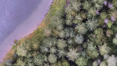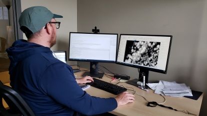
Intern Jamie Albino details the forestry intelligence research projects taking place at the Skattebo Education Forest.
The Skattebo Education Forest is located on the east shore of the Kootenay River between Nelson and Castlegar, just south of the community of Glade. Classes from natural resource diploma programs visit Skattebo to participate in field trips where they collect forest, fisheries and ecosystem data and learn to interpret this information.
Skattebo also provides Selkirk Innovates researchers with the perfect location to test new technology and techniques in projects that benefit local communities, industry, and the environment.
Conducting Real-World Research
Principal investigator Dr. Brendan Wilson leads this suite of forestry intelligence research. “We’re very excited about the work we’re doing in Skattebo,” says Wilson, “because it connects learning with real-world applied research.”
Skattebo research projects are currently testing methods to identify individual trees in the forest, quantify common forest stand metrics, determine canopy heights, determine tree health status, identify cones for seedstock, assess understory fuels and more.
These projects use drones—also known as remotely piloted aircraft systems (RPAS)—and a variety of sensors to collect imagery and laser scan data. Photogrammetry software is used to stitch the raw images together into high-resolution single products called orthomosaics. Aerial laser scans, usually referred to as LiDAR (Light Detection and Ranging), produce “point clouds,” which are dense clouds of millions of points representing accurate locations in 3-D space. LiDAR is especially useful because it penetrates the dense “Kootenay mix” forest canopy, providing information about the ground surface and vegetation below. Researchers analyze these products using the latest geospatial and statistical software, alongside powerful machine learning and artificial intelligence techniques to develop new methods for understanding forests and ecosystems.
Reducing Wildfire Risk
The Skattebo Wildland Urban Interface (WUI) project is an ongoing effort funded by the Province of BC, the Columbia Basin Trust’s Wildfire Resiliency Initiative Program, and NSERC's Applied Research and Technology Partnership grant program. Data collection and analysis in 2023 built on work done in previous years, with researchers successfully conducting multiple flights of LiDAR, RGB and multispectral sensors. Post-treatment LiDAR scans were completed for the first phase of wildfire fuel reduction, which was managed by CABIN Resource Management. This treatment of six hectares reduced wildfire risk by removing ladder fuels, which in Skattebo are typically smaller trees that could spread fire from the ground to the larger tree canopies. These fuels were then piled and burned during optimal burning conditions in late winter and early spring.
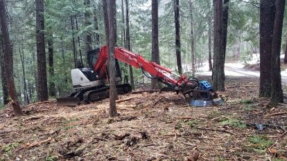
Pre-treatment scans for the second phase of the WUI project were also completed in 2023. This phase will reduce ladder fuels in an additional 10 hectares of Skattebo. The treatment prescription for the second phase was developed in consultation with the Ministry of Forests and consists of mulching fuels in place. This experimental WUI prescription may offer benefits versus piling and burning in terms of cost and smoke reduction, and forest floor biomass retention. The second phase treatment is ongoing and expected to be completed by spring of 2024 by Agrofor Ventures, at which time post-treatment RPAS data collection will be conducted.
Empowering Effective Action
Researchers are hoping to use these datasets to quantify fuel reductions in the forest by comparing the pre- and post- treatment LiDAR scans. Future efforts will compare RPAS scans to ground-based fuels data to determine how fine-scale remote sensing can complement traditional forestry methodologies. The goal is to provide forest managers with methods to collect high-quality data quickly and safely, over larger areas than would be practical using traditional ground-based methods. This will empower effective action to mitigate wildfire risk, protecting both forest resources and nearby communities.
Other current research is focused on multispectral and RBG (e.g., normal colour) imagery collected in 2023. These imagery datasets were processed using random forest machine learning to classify tree species based on their spectral characteristics. The random forest algorithm builds many different decision “trees” to identify which spectral characteristics can be used to differentiate between tree species. It selects the best-performing decision tree as the model, which is used to calculate the probability that each pixel in the imagery dataset belongs to a given tree species.
The preliminary Skattebo species model correctly predicted the species of individual trees approximately 80% of the time. This matches other earlier student research work using convolutional neural networks (CNNs) that predicts tree species identification for complex low-elevation West Kootenay forests such as Skattebo.
Assessing Tree Health
A similar branch of inquiry concerns tree health: the same spectral data that can predict tree species may also prove effective for identifying stress in individual trees. A variety of tree diseases and stressors impact British Columbia’s forest resources each year, including insects, fungal infections and drought. Many of these conditions are expected to worsen under a changing climate. Forest health data collected by Forest Technology students in 2023 will be used by researchers as they begin exploring this potential application of fine-scale remote sensing. Accurate early detection of tree stress would allow forest managers to proactively manage unfavorable conditions in forest stands, potentially preventing larger outbreaks of pests, for example.
Forestry intelligence projects seek to advance the ways in which forest data is collected and analyzed. In all cases, these efforts drive toward developing tools that complement traditional ground-based forest data collection. Further work is necessary to better integrate these methods. Once this is achieved, resource managers will be able to generate detailed and accurate inventories of select forest resources. Forest managers face uncertain ecological and economic conditions that challenge existing inventory and stewardship practices. The Skattebo Education Forest continues to support learning and research to meet the challenges of a rapidly changing environment.
With gratitude, we acknowledge that Skattebo is the traditional territory of the Sinixt (Lakes), the Syilx (Okanagan), the Ktunaxa and the Secwépemc (Shuswap) Peoples. We request that users treat the area with due respect and avoid activities that negatively impact the ecosystem and learning environment.


